 From the Delta to the High Desert
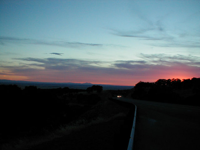
Wow. You must check
this out. Taken at around 8 pm on the final leg of a day-long drive
over the Sierras, this sunset was an awesome surprise as I came over a hill on
CA 4. The colors are brilliant, but what really amazed me was the view itself.
You can see across the entire Central Valley, a concept I'd been led to believe
had disappeared a long time ago. But those two "humps" are Mt. Diablo and its
cousin (don't know its name), and the range running off to the left is part of
the coast range. When you drive down I-5 from Stockton or Sacramento you drive
at the foot of those hills. It was that realization which led to my somewhat
amazed response to the view. Oh, and did I mention the colors?
So that was the end of the drive. The point (and all of my day-long excursions have a point) of this one was to drive on CA 167, located waaaay out at the eastern edge of California, right next to Mono Lake. On the map it's a perfectly straight line from Mono Lake to the Nevada border. It's only about 21 miles (21.33 according to Caltrans), so it might seem silly to first drive 200 miles for the purpose of driving a special 21. Not to worry though. There was plenty of scenery and places I hadn't seen along the way, and I got to go through Yosemite National Park along the way.
I knew it would be a long drive just to get to Mono county -- it is on the other side of the Sierra Nevada don'tcha-know -- so I resisted stopping to take a bunch of pictures of every scenic overlook or interesting road sign along the way. Climbing up CA 120 is the usual pretty drive -- from farmland to oak savannah (my favorite) to pine, and even the $20 entry fee to continue through Yosemite wasn't so bad. Still, how could you not stop and look at this? Or this? That's the view looking toward Yosemite Valley from Olmsted Point. That big hump-thing in the distance is Half Dome, icon of Yosemite and indeed of all California. Ah, but I had to move on. As Prof. Cole used to say, "Onward and upward." To almost 10,000 feet above sea level (yes, I have an altimeter in my car--you're not surprised are you?). The road over Tioga pass (highest road pass in California) is closed in the winter and one can only imagine what this landscape looks like in mid-January. Here's another shot. Yesterday, though, the sky was perfectly clear and the trees were tall.
You leave Yosemite at the Tioga Pass booth and at that point you officially resume CA 120 for the steep descent into the Mono Scenic Area which sits at around 7000 feet. The change in topography is as impressive as the previous climb, and the drive down into Lee Vining Canyon offers ample opportunities to take it all in. You'll notice that there are essentially no trees on this side of the Sierras. At the bottom of the descent you get an amazing shot of the towering mountains behind you before continuing along CA 120 into the town of Lee Vining. By the way, the Tioga Pass Road, over which I'd just driven, is apparently famous in engineering circles, and you can get an idea of the challenges involved in getting the road built.
After pulling into a scenic overlook to gaze upon Mono Lake (another) I had lunch in Lee Vining at a nice restaurant called Nicely's (ha), but since it was approaching 4 pm, I had to get going. Fortunately, it's a short drive north on US 395 to the start of CA 167.
As I drove along, I decided that CA 167 had to be the loneliest CA highway ever. Sure, there are other highways in California that are remote, but there's something about the particular kind of desolation and utter straightness that makes CA 167 different. Sure, I was passed by three other cars coming from Nevada, but I was struck by the idea that someone actually said, "hey, we need the road to Hawthorne, NV to be a California highway." I assume it was because of the inter-state characteristics of this 21-mile strip of asphalt which made the highway designation necessary, but it all seemed so alien to me. At the same time, I thought this is what I like about California -- the contrast that's available. I'd already crossed one of the world's most famous mountain ranges after starting in one of the world's most productive agricultural regions, and now I'm driving in a straight line along a desolate highway through the beautifully desolate countryside of eastern California, and all in one day. Finally, CA 167 ends just short of the border and you turn around.
I happened to glance at the map and noticed the presence of CA 270, just up US 395 a bit. It seemed short enough to squeeze in before I had to head back to Stockton, so I went for it. Also a strange road -- its sole purpose is to get you only part of the way to Bodie State Historical Park. Bodie is a ghost town, but I wanted to save it for another day. As you can see, the pavement ends and I didn't feel like off-roading. So, another turn around and back to 395. By the way, I found a nice map of all this.
My route home would be CA 108, which starts at US 395, heads over the Sierras, and then ends in Modesto. Just as my descent from Tioga Pass had been steep, my ascent to Sonora Pass would be steep, in many cases much more steep, and much windier (as in the road having lots of turns, but it was also quite windy, as in blowing air). The sign at the start of the highway warned of a 26% grade in some places. 26%!!! Could you imaging coming down that? And, you're climbing that grade at 8000-9000 feet, so your car is just gasping for air. Pretty wild. All of a sudden though, you pop out at the summit only to begin the long descent back into the Central Valley. Since Modesto was too far south, once I got down into the foothills I cut across the north side of Tulloch Lake to catch CA 4 the rest of the way home. And that's when I saw the sunset.
Oh yea, mountain driving is great for gas mileage (lower speeds but fairly constant motion). The whole trip was 423 miles and I did it on one tank of gas with plenty to spare. Weeeee!
Posted: Friday - August 06, 2004 at 11:45 AM
Quick Links
Statistics
Total entries in this blog:
Total entries in this category:
Published On: Aug 02, 2007 07:02 PM
Total entries in this category:
Published On: Aug 02, 2007 07:02 PM